According
to a survey made in 1996 it is estimated that in Maharashtra State
2,00,000 hectares of excellent agricultural land is affected by
salinity. Non-coastal saline soils occur in low and moderate rainfall
zone of Maharashtra. The causes of this kind of soil deterioration
are :
i)
Low rainfall coupled with impeded drainage condition in heavy
deep black soils.
ii)
Low lying situations receiving salt washes from uplands and causing
upward salt movement
iii)
Indiscriminate use of irrigation on heavy soils and over-emphasis
on perennial irrigated crops.
With each passing year salinity is spreading to new areas. It
needs to be tackled systematically. Reclamation of such soils
is rather difficult because they contain highly expanding type
of clay. However, by means of a systematic approach reclamation
is possible. A technological package needs to be developed for
this region on the basis of systematic data. Sangli district is
chosen for in-depth study and for implementation of a pilot project.
In absolute terms salinised area in Sangli District is reported
to be 54,000 hectares.
Choice
of Kavathe Piran
Kavathe Piran village is situated 12 km. west of Sangli town.
It is a part of the chronically affected area which lies between
Krishna and Warna rivers. In 1997 and 1998 the salinity affected
area of the village (800 hectares) was taken up for treatment
by Verala Development Society (VDS), pursuant to the request made
by the village Panchayat to Shri Arun Chavan. The villagers were
asked to form a representative committee. The committee collaborated
with VDS and the Villege Panchayat.
The members of affected families willing to actively participate
in the project is 446. They are from different social strata,
including depressed classes, minorities as well as caste Hindus.
The project implementation committee represents all these sections.
Technical
expertise
Two
experts, an agronomist and an agriculture engineer, attached to
the Agriculture Research Station, Digraj, which is a part of Mahatma
Phuley Agri. University have provided technical know-how to the
Project.
The survey made in 1995 has revealed that the entire stretch of
salinity affected track of Kavathe Piran has all the three types,
namely, (i) saline (ii) saline-sodic and (iii) sodic. The three
represent three progressive stages of soil sickness. Saline soils
can be reclaimed with the application of physical correction measures,
that is, water flushing. In regard to saline-sodic and sodic soils
chemical correction measures alongiwith water-flushing is necessary.
Activities
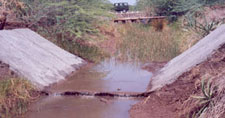
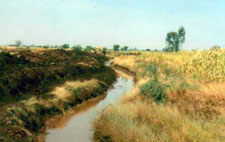
The
reclamation programme consisted of physical correction of the
land. The 6 km. long Main Drain (The Nalla) and the two subsidiary
drains were deepened by excavators. Excavated silt was spread
on either banks of the drains to an average breadth of 200 meters
on each side. The thick jungle of throny shrubs was swept aside.
About 400 hectare area was thus cleared and levelled up. The Main
Drain functioned optimally from May 1998 onwards. One hundred
hectares in the proximity of the Drains are under regular tillage
by the farmers and near normal yields are produced.
Particulars
of Field Activity
(1) The project commenced on 1.5.1996. In the first part a demonstration
area of 100 acres at the upper reaches of the Main Drain was taken
up.
(2) The second part which covered treatment of the entire 6.0
km. length of the Main Drain which falls within Kavathe Piran
land area was taken up on 1.1.1998 and was completed on 1.3.1998.
The programme comprised (a) deepening of Main Drain (b) removal
of shrubbery and (c) levelling of lands on either bank with an
average breadth of 200 meters each. The following quantities were
involved.
(1)
Earth Work
(a) Deepening of Main Drain
i) Main Drain : Length-- 6.00 k.m. approx.
ii) Subsidiary drains :
Length -- 2.40 k.m.
2400 mtrs.
Av.Breadth -- 3.00 Mts.
Av.Depth -- 1.50 Mts.
Quantity 10,800.00 Cu.M.
Total 22,800.00 Cu. M.
(b) Spreading of excavated material
Total qty as above ------- 22,800 Cu.M.
+ Work done by Local Sugar Factory
6000 X 8.00 + 2.00 X 2 = 60,000 Cu.M.
----------- Total 82,000 Cu.M.
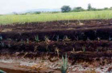
I.
In demonstration Plot No. 1 underground drainage system was laid
in January 2000. Its design was based on the surveys and studies
made in 1999. In November 2000 and in October 2001 wheat was sown
on one plot. The per-acre wheat yield was 0.60 tonne which came
to the near average yield from normal soil from similar agro-climatic
zone. The demonstration amply proved that the plot under treatment
was free from salinity.
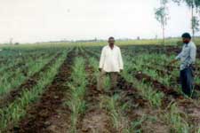
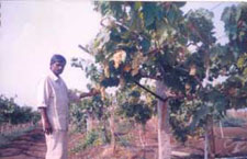
In demonstration Plot No. 2 horticulture varieties were planted.
The rootstock of Dogridge Grape and Saltcreek Grape were planted
in January 2000. In November, 2001 the first crop of grapes was
gathered. The per acre yield was 2 tonnes. The second year’s
grape harvest was sumptuous : In March, 2003 the per acre yield
that was registered was 5 tonnes; and its quality was excellent.
Significance
Significance
of this successful trial cannot be over-stated. The experts from
the National Horticulture Research Institute, Hyderabad have visited
the demonstration site and have opined that this was the first
successful trial of its kind on saline soil in India.
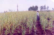
The young farmer from the village Uday Suryavanshi has planted
3 acres of Thompson seedless grapes on his farm which lies within
the salinity affected zone of Kavathe Piran. In April, 2005 he
will take his first crop. Our personal assessment is that the
per acre quantity would be 10 tonnes of excellent quality grapes.
Another young farmer from the same village named Pirgonda Walavade
has planted half an acre of seedless grapes and the trend is likely
to grow.
Development
of Technology
Desalination
methods used in the plains of North India need to be modified
in view of the topographical features of the Deccan Plateau. It
can be said without fear of contradiction that we have developed
efficacious method of desalination of the saline lands in the
river valleys of the Deccan Plateau.
(I)
Project sustainability will flow from long-term functionalisation
of the natural drainage system. For this purpose, the rational
unit of treatment is the local watershed. A local watershed straddling
the landmass between the ridge and the river or a big stream with
a stable flow-channel, is the Nature-made unit for desalination
operation. The distinguishing geo-physical property of the watershed
is its well-marked boundaries. A watershed acts as a receptacle
of water which flows into it, either as groundwater, or in the
form of run-off or as excess generated by surface irrigation.
The excess from it can flow out of it only through the drains
made by Nature or by man. In their absence it will remain static
within its confines. The landmass of the Deccan, is divided into
river valleys, and these valleys in turn comprise a series of
local watersheds. Treating them as separate units for the application
of the desalination process is both a rational and economical
method. This method also affords ample scope for farmer participation
which is essential for safeguarding the sustainability principle.
Watershed-wise application of the corrective procedure guarantees
sustainability to the desalination project as it is in harmony
with soil property and water behaviour in the given conditions.
The concept of watershed-wise treatment of saline lands has emerged
out of the practical experiments carried out by VDS between 1996
and 2003. It is a solution pertinent to the problem as viewed
in the geo-physical situation and the context of the farmers’
socio-economic status, which is defined by small size of land
holdings (ranging between 1 to 10 acres).
(II)
Efficacious method of achieving sustainable desalination largely
depends on long-term functionalisation of the Main Drain and its
subsidiaries. That in turn depends on obviating the frequent need
for desilting and deepening of the drains. Because it is prohibitively
expensive and well beyond the organisational and economic means
of the beneficiaries, the farmers.
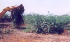

 Giving
Vegetal cover for main drain
Giving
Vegetal cover for main drain